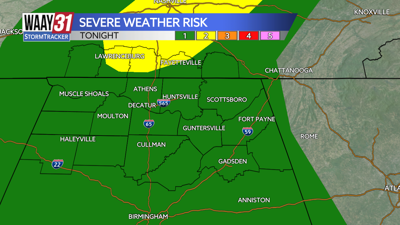


** LOW END SEVERE WEATHER RISK IN PLACE TODAY **
Multiple cold fronts are set to push through the Tennessee Valley this weekend, the first one arriving today. With it comes a limited risk of strong to severe storms this evening.
Waking up this morning, temperatures are sitting in the mid to upper 50s, with highs reaching the low 70s by the afternoon. A few isolated showers are possible this afternoon, but as we head into the evening hours, a broken line of storms is expected ahead of the cold front. The main threats will be damaging winds and hail. The tornado risk is very low—but never zero.
Partly cloudy skies with highs in the low 70s are expected Saturday, as we’ll be between cold fronts. A shower or two is possible Saturday evening, but most areas should stay dry.
Sunday marks the start of our major cooldown, with highs beginning in the low 50s and falling into the 40s by the afternoon.
The cold continues to settle in early next week. Highs on Monday may not get out of the 30s, with wind chills possibly dipping into the teens. A few snow flurries or snow showers are possible, but no accumulation is expected.
A hard freeze is likely Tuesday morning as temperatures start in the mid 20s. From there temperatures will be on a steady climb going from around 50 Tuesday afternoon back to around 70 by next weekend.
FRIDAY: Mostly cloudy with a slim shower chance. A few storms arrive by evening. Highs in the low 70s. Wind: SW 6-12 mph.
TONIGHT: Stronger storms possible, lows in the upper 50s. Wind: SSW 5 mph, gust up to 20 mph.